Hangar One Services
SAFE - EFFICIENT - ECONOMICAL
Working smarter and safer collecting highly accurate data and photogrammetry using the latest drone technology, streamlining workflows in the property, construction and energy sectors across the UK. We are based in Leyland Lancashire with superb access to the motorway network.
Construction Surveys
If you have experience of active construction sites, you will appreciate how busy and hazardous they can be. This can make it extremely high risk for anybody attempting to carry out a comprehensive site or material inspection. This is where we specialise!
We have the capacity to deliver highly detailed aerial images without the need for project managers or quantity surveyors setting foot on the active construction site to capture the data required. We deliver high definition digital files captured with enterprise level camera equipment ultimately eliminating health and safety risks and disruption on site our deliverables can be viewed on desktop PC's, Laptops, or mobile devices
HD Aerial Photography
Our aerial photography and media services utilise the latest Unmanned Aerial Vehicles (UAV) drone technology offers our clients a superb combination of stunning HD aerial video and impressive aerial photography across the UK.
Our enterprise level drones (UAV's) provide an innovative alternative to traditional expensive workflows to provide high quality images at a fraction of the cost. Operating at various altitudes we can actually provide more flexibility over these more expensive traditional methods of capturing your aerial photographs. Hangar One has everything you need to ensure your shoot is a success. Including image editing and touch-ups, their range of professional services ensure you’ll receive the picture perfect outcome. Get in touch to find out more about our services.
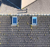
Roofing Inspections
One of our most requested services, roofing surveys, reporting on roof condition and fault finding using our UAV (Unmanned Ariel Vehicle) or drones allows our fully qualified operators to monitor, photograph and view the current state of any building from above which would normally be out of reach of traditional inspection methods. Our reports prove invaluable when considering asset management for commercial or domestic Buildings & structures.
Drone Roofing Inspections / Surveys can be delivered much faster and negates the need for high level access which eliminates health and safety issues and often very costly, access equipment which can also have restricted operational reach. We can also offer RICS accredited surveys, UHD 4K images, and Thermal Imaging options.
3D Modelling & Point Cloud
We have the ability to create and visualize highly accurate 3D models using Point cloud, which is a collection of data points in space produced by utilising the very latest RTK technology and the most advanced photogrammetry software available to the industry.
This service is particularly useful for asset management and BIM (building information modelling) to create a digitized version of any building or structure. We can effectively deliver your virtual asset in digital format to view at your desk, laptop or even mobile device! For more information regarding 3d Modelling or point cloud processing don't hesitate getting in touch.

Point Cloud explained: A point cloud is a set of data points in space, usually defined by the X, Y, and Z coordinates of the points. It is commonly used in computer graphics and computer vision to represent 3D shapes, objects, and surfaces. Point clouds can be captured using technologies such as LIDAR (Light Detection and Ranging), stereo cameras, or structured light sensors. Point clouds can be used in a variety of applications, including: 3D modeling: Point clouds can be used to create 3D models of real-world objects and environments. Scene reconstruction: Point clouds can be used to recreate 3D scenes from 2D images or video. Quality inspection: Point clouds can be used to inspect the quality of manufactured objects and parts. Virtual and augmented reality: Point clouds can be used to create immersive virtual and augmented reality experiences. Autonomous vehicles: Point clouds can be used to help autonomous vehicles navigate and understand their surroundings. Point clouds can be processed and analyzed using various algorithms to extract features, detect shapes, and perform other tasks. They can also be compressed to reduce the amount of data that needs to be transmitted or stored. Point clouds are often large in size, making processing and storage challenging, this is where Hangar One excel. We collect the point cloud data, process, and store your digital data. Providing you with the ability to revisit your data at any time online.

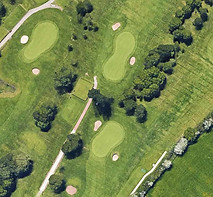
Topographical Survey
This type of survey is regularly used in construction, engineering, and land development projects, as it provides detailed information about the land’s topography such as accurate location, height and depth using the latest RTK technology. We can also deliver volumetric surveys for keeping track of construction materials and aggregate stocks.
The purpose of a topographic survey is to gather spatial data relating to the specified sites features whether they are natural or man made. We use the National Ordinance Survey grid and datum information along side RTK (real-time kinematic) when running topographical surveys.
Infrared Thermal Imaging
Hangar one have the capacity to deploy UAV's or drones with dedicated infrared / thermal imaging payloads which are capable of detecting heat sources from any area in the drones flight path that are totally invisible to the human eye. This enables end users to detect any faults, heat leaks and identify potential issues before they become critical.
How do thermal drones work? Thermal images are generated by collecting and analysing the heat signature being emitted off a subject. Drones with thermal cameras use an infrared (IR) camera to generate thermographic images, displaying differing temperature values of a scene.

-
Environmental advantagesSome environmental advantages of drones include: Reduced carbon emissions: Drones are powered by batteries and emit fewer pollutants compared to traditional vehicles or aircraft, which can help reduce carbon emissions and air pollution. Environmental monitoring: Drones can be used to gather data on air and water quality, as well as to detect pollution and other environmental hazards, helping to improve environmental monitoring and response. Renewable energy: Drones can be used to inspect and maintain wind turbines and solar panels, reducing the need for workers to climb towers or travel to remote locations. Overall, drones can play an important role in promoting sustainable practices and protecting the environment.
-
Health and Safety Risk ReductionUtilising drone technology we can massively improve the current risk factor within your company. Currently, around a third of all fatalities in the workplace are due to falls from height, with almost two thirds attributed towards serious injury from slips, trips and falls. Hangar One Ltd aim to help reduce these numbers by avoiding the requirement for manual visual inspection at source. The latest drone technology provides a much safer solution towards your maintenance routines.
-
Reduced Site DisruptionOur drones are capable of covering a huge amount of ground a much faster than traditional methods and can be in flight within minutes of arriving on site. The UAV inspection process can then be completed the same day, generally not requiring any prolonged shutdown, isolation requirements, or specialist access equipment which can prove expensive for your business.
-
Huge Cost ReductionConsidering the points above, one of the massive benefits of utilising drones or UAV's is the cost implications for your business. This becomes This is especially true during routine preventative maintenance inspections.
Contact Hangar One
If you think we can help with your requirements, don’t hesitate. Contact Hangar One Ltd today.
+44 (0)1772 230735
damian@hangar-one.co.uk
matt@hangar-one.co.uk
Company name – Hangar One Ltd.
Registered address – 14C Boxer Place, Leyland, PR26 7QL
Company number – 13808819
Company jurisdiction - Company Registered in England & Wales
Office Location
Social media Channels
hangar.one
hangar0ne
Hangar_One_
Hangar_One_
@hangarone
Approved & Qualified Operators
We are CAA + GVC Qualified, fully insured and approved Drone operators.
Cof C is the qualification needed to operate in the A2 Subcategory of the OPEN Category under the new UAS regulations.